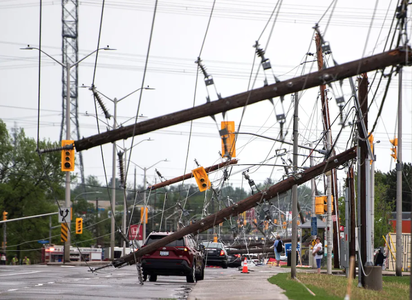
A line of violent thunderstorms tore across the most populous corridor of Canada, killing at least 10 people and cutting power to nearly a million people.
The storms carved a path of destruction from southern Ontario to southeast Quebec, passing close to or directly through three of Canada’s four largest cities: Toronto, Montreal and Ottawa. Pearson International Airport, which serves the Toronto metro area and is the largest airport in the country, measured a wind gust of about 75 mph. Ottawa International Airport, another major hub, also recorded a 75 mph gust.
Environment Canada, the nation’s weather and climate agency, reported at least 10 deaths and several injuries because of strong winds. It also reported “extensive damage to trees, power lines and buildings,” as well as overturned cars and widespread outages.
Several of the fatalities were caused by falling trees, including at a golf course and a conservation area. One woman died when her boat capsized on the Ottawa River in Quebec, according to local media, and another women died Sunday after being hit by a falling tree branch in the storm’s aftermath.
“My thoughts go out to both of their families & friends and I offer condolences on behalf of all Ontarians,” Ontario Premier Doug Ford tweeted Saturday evening.
Hydro One said Monday that some 196,000 people remained without power in Ontario. Crews from as far away as the Atlantic province of New Brunswick had been called in to help, the utility said in a tweet. In Ottawa, the city set up reception centers for affected residents.
“We’re thinking of everyone affected, and thanking the crews who are working to restore power,” Prime Minister Justin Trudeau said in a tweet Sunday. “We stand ready to provide federal support if needed.”
Several of the deaths underscore a common theme in severe wind events: Those participating in outdoor activities are particularly vulnerable to violent wind gusts. The U.S. Storm Prediction Center website says that “those involved in outdoor activities are especially at risk,” particularly “campers or hikers in forested areas,” who “are vulnerable to being injured or killed by falling trees.”
Widespread damage to trees and power infrastructure also dealt a hefty blow to electrical distribution in the urban corridor. As of Saturday evening, power outage aggregator PowerOutage.com listed about 925,000 outages in Quebec and Ontario, a massive event for a country with just over 38 million citizens.
Emergency crews responded to more than 500 calls on Saturday for downed power lines, fires, fallen trees and damaged buildings, CTV Ottawa reported.
The storm complex almost certainly qualified as a derecho, or a thunderstorm complex that produces extremely powerful wind gusts across a wide swath. The effects from a derecho’s violent winds are often comparable to those of hurricanes. Derechos are fairly common in the Lower 48 states but are more rare north of the border and seldom affect such densely populated corridors.
Derechos often strike along the northern periphery of heat domes, where conditions are ripe for powerful thunderstorms. Indeed, very unusual early-season heat swelled over eastern North America on Saturday, with numerous cities in the eastern United States setting records.
The combination of this heat with moisture pulled north from the Gulf of Mexico encouraged extreme atmospheric instability, or fuel for thunderstorms, in eastern Canada. The storms erupted as this hot, moist air was met by a strong cold front marching eastward. This was the same cold front that caused temperatures in Denver to plunge by more than 50 degrees in 24 hours and helped spawned the deadly tornado in Gaylord, Mich.
Historically, far southeast Canada sees approximately one derecho event every four years, according to the Storm Prediction Center. But Saturday’s event was unusually far northeast and hit at an uncommon time of year; many Canadian derechos have struck in July or August.
The unusual characteristics of Saturday’s derecho may have been representative of a climate change-related trend in the location of such damaging thunderstorm events. According to the Storm Prediction Center website, “The corridors of maximum derecho frequency likely would shift poleward with time” as warm domes of high pressure expand north under global warming.
