A potentially epic December heat wave is set to blanket much of the contiguous U.S. over the next two weeks, potentially leading several cities and states to set records for the warmest first month of winter on record.
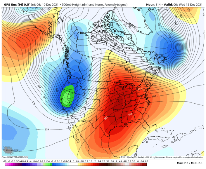
The big picture: In a major pattern shift, the jet stream is poised to dive south toward the western U.S., bringing much-needed rains and mountain snows to a parched California and other western states. But to the east of this jet stream dip, or trough, a potentially record strong ridge of high pressure is projected to set up over the Central U.S.
- This ridge will be responsible for the record warmth, but it’s in keeping with trends from human-caused climate change.
The details: December has already been unusually mild in many areas, with Denver and Salt Lake City recording their latest measurable snowfalls on record, and the Houston area tying its hottest recorded temperatures seen for the month on Thursday, when highs reached the mid-to-upper 80s.
- The warm weather looks to build starting early next week in the Plains, South Central states, and Gulf Coastal region. The highest temperatures compared to average are likely in the eastern Plains on Tuesday, Wednesday and Thursday, with colder air not projected to start pouring in from Canada until Christmas or soon after. Even then, the East Coast is still likely to be unusually mild.
- There is virtually zero chance of a white Christmas in cities including St. Louis, Kansas City, Columbus, New York City, Boston, Washington, D.C., and points south.
According to the National Weather Service, some areas may see temperatures running 20°F to 40°F above average for this time of year, as the record strong area of high pressure builds aloft. This high will ensure plenty of sun, sinking air, which helps to increase temperatures through compression.
- The clockwise flow of air around the high pressure area will bring an airflow from the southwest, a mild direction.
Map showing the large area of unusually warm air associated with the strong area of high pressure aloft, located east of the Rockies in mid-December. (Weatherbell.com)
- The entire U.S. east of the Rockies look to be much milder than average on Dec. 15, with the greatest anomalies predicted for Iowa, eastern Nebraska, Missouri, parts of Illinois, Oklahoma, Kansas and Indiana.
- As this time period gets closer, the forecast is likely to be refined, however, since there is some uncertainty about how far north temperatures in the 60s and 70s will progress.
- Two areas that may miss out on the warmth are the Upper Midwest and Northeast, where cold air may continue to filter in from Canada.
Threat level: The intensity of the heat wave is somewhat uncertain, but multiple computer models depict a weather pattern that could produce an event of historic proportions, with temperatures in the 90s along the Gulf Coast, and possibly near 80°F surprisingly far north in the Plains states.
- While a December warm spell might be a welcome occurrence for some, extreme weather events can disrupt ecosystems and infrastructure.
Context: There is also climate change context to this heat wave. Winter is the most rapidly warming season in the U.S. (meteorologists define winter as the months of December, January and February).
- In Des Moines, for example, the average winter temperature has increased by 4.5°F since 1970, with 11 more days with highs above a particular threshold, according to data from the climate research and communications organization Climate Central.
- And in Minneapolis-St. Paul, the average winter temperature has increased by 5.7°F since 1970.
- The world is headed for another top 10 warmest year in 2021, despite the presence of a cooling La Niña event in the tropical Pacific Ocean.
- Additionally, meteorologists have observed increasing instances of unusually strong, stubborn areas of high pressure aloft in recent years that have been associated with extreme weather events, including heat waves.
Yes, but: There is some extreme cold to be found when one zooms out to look at the big picture, particularly in the Arctic, where Alaskans have been shivering through one of their coldest starts to winter in years.
- Meanwhile in Siberia, temperatures of minus-50°F have been recorded in some of the same areas that saw record heat and wildfires last summer. Some of these fires are still smoldering under the snow pack and could reemerge during the spring.
- Such blazes are known as “zombie fires.”
- Source: Yahoo News
