By ROGER SIMMONS and LISA MARIA GARZA . ORLANDO SENTINEL |AUG 25, 2019 | 7:42 PM
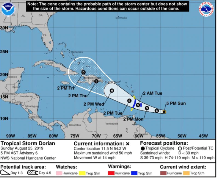
Tropical Storm Dorian is beginning to strengthen, National Hurricane Center forecasters said Sunday evening, and they believe it will become the first hurricane of the season by Tuesday.
In its 8 p.m. Sunday advisory on Dorian, the hurricane center said the tropical storm was located about 335 miles east-southeast of Barbados and 445 miles east-southeast of St. Lucia. The storm was moving west at 14 mph with maximum sustained winds near 50 mph with higher gusts.
“Additional strengthening is expected during the next few days, and Dorian could be near hurricane strength by Tuesday over the eastern Caribbean Sea,” hurricane center forecasters said.
“While it is too soon to determine the specific time or magnitude of possible direct impacts in Puerto Rico, the Virgin Islands, or Hispaniola interests in those areas should monitor the progress of Dorian,” they noted.
Forecasters said that Dorian is expected to move generally west-northwestward for the next several days and start impacting some Caribbean islands.
“On the forecast track, the center of Dorian is expected to be near the Windward Islands late Monday or early Tuesday and move into the eastern Caribbean Sea on Tuesday,” the NHC said. “While it is too soon to determine the specific time or magnitude of possible direct impacts in Puerto Rico, the Virgin Islands, or Hispaniola interests in those areas should monitor the progress of Dorian.”
Tropical Storm Warnings have been issued for Barbados, St. Lucia, St. Vincent and the Grenadines , while a Tropical Storm Watch is in effect for Martinique, Grenada and its dependencies, the hurricane center said.Computer models for Tropical Storm Dorian »

As of Sunday afternoon, Dorian’s tropical-storm-force winds extended outward up to 35 miles from its center.
In a forecast discussion posted on the National Hurricane Center site, it was noted that the storm’s development is being limited by nearby dry air. “This could slow intensification despite an environment of light to moderate shear,” the NHC noted.
In its “key messages” about the storm, the hurricane center said, “Dorian is expected to bring tropical storm conditions to portions of the Lesser Antilles, where tropical storm watches and warnings are in effect. Residents in these areas should refer to advice from local government officials and products from their local meteorological service for additional information.”
Forecasters also said the storm is likely to bring 2-4 inches of rain — with isolated amounts as high as 6 inches — across portions of the Lesser Antilles.

Meanwhile, forecasters are still watching a low pressure system off the coast of Florida that is expected to move farther into the Atlantic away from the state and has a 80 percent chance of becoming a tropical depression in the next five days.
“Interests along the coasts of South and North Carolina should continue to monitor the progress of this system,” forecasters said “.An Air Force Reserve Hurricane Hunter aircraft is scheduled to investigate the system on Sunday, if necessary.”
A small system that popped up on the Texas coast on Saturday had dissipated by Sunday morning.