By TIFFINI THEISEN ORLANDO SENTINEL |AUG 28, 2019 | 8:10 AM
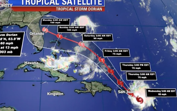
Tropical Storm Dorian strengthened overnight as Puerto Rico and the U.S. Virgin Islands were warned to brace for hurricane conditions with possible heavy rains and “life-threatening” flash floods today, the National Hurricane Center said in its 8 a.m. Wednesday update. The storm is expected to grow in size and could hit Florida as a Category 2 hurricane by late Sunday or early Monday.
Overnight, winds picked up to 60 mph as the storm made its expected northwest turn, and a hurricane watch was issued for Puerto Rico, Vieques, Culebra, and the U.S. Virgin Islands. President Trump declared an emergency Tuesday night and ordered federal assistance for local authorities.
Dorian is expected to strengthen into a hurricane as it approaches landfall on Florida’s east coast. Parts of Florida could expect 4 to 8 inches of rain, and up to 10 inches in isolated areas later this week and into early next week.
“The latest forecast track shows the potential for a Category 2 hurricane impacting Central Florida by late Sunday into Monday morning of next week,” Fox 35 meteorologist Jayme King said early Wednesday. “Floridians need to be prepared and take this latest development seriously.”

NHC forecasters said early Wednesday that “nearly all of the intensity models show Dorian becoming a hurricane in about 2 days, with additional strengthening beyond that time … The threat of tropical storm or hurricane conditions, along with storm surge, in the northwestern Bahamas and along portions of the Florida east coast have increased.”
The hurricane center’s updated track projected that Dorian could be off the coast of Titusville by 2 a.m. Monday, but the cone of uncertainty shows it could also be anywhere from the southeastern tip of South Carolina to the Everglades or west of Florida in the Gulf of Mexico by that time.
“Exact impacts of this system remain unclear at this time, much will depend on the landfall location and strength of Dorian during that time,” Fox’s King said. “Forecast modeling is suggesting more of an adjustment of the storm’s path keeping landfall possibly closer to Jacksonville or even the Carolinas, though we need to monitor this possible trend over the next day or so.”
In addition to a hurricane watch, a tropical storm warning is also in effect for Puerto Rico, Vieques, Culebra, and the U.S. Virgin Islands.
Additionally, a tropical storm warning is in effect for the British Virgin Islands.
A tropical storm watch is in effect for the Dominican Republic from Isla Saona to Samana.
At 8 a.m., Tropical Storm Dorian was located about 60 miles southeast of St. Croix and continuing to move northwest at 13 mph, after having made its expected northwest turn overnight. Tropical-storm-force winds extended outward up to 60 miles from the center.
The change in the storm’s course concerned many across the U.S. territory, where some 30,000 homes still have blue tarps as roofs nearly two years after Hurricane Maria. The island’s 3.2 million inhabitants still depend on a shaky power grid that has remained prone to outages since it was destroyed by the Category 4 storm.
Although top government officials in Puerto Rico said they were prepared for the storm and had sufficient equipment, a couple of mayors, including those in the western region, said they did not have enough generators or shelters that were properly set up.
U.S. Sen Marco Rubio, R-Florida, said in a tweet Tuesday that he would work with Trump to get Puerto Rico any resources it needs.
Puerto Rico Gov. Wanda Vázquez urged those living in flood-prone areas or under a blue tarp to move into one of the island’s 360 shelters on Tuesday night. Housing Secretary Fernando Gil has said some 9,000 to 13,000 homes with blue tarp roofs are located in the region that Dorian is expected to affect the most.
Officials also said public schools and government offices would remain closed through at least Thursday.
Meanwhile, a system that had been hanging around Florida before heading out into the Atlantic and became Tropical Storm Erin picked up a bit of speed overnight as was moving north-northwest at 6 mph, with maximum sustained winds of 40 mph at the 8 a.m. Wednesday update. It’s expected to strengthen slightly today before becoming an extratropical cyclone, the hurricane center said.